Key Biscayne’s Heritage Trail
Franklin CaplanFebruary 19, 2019

Key Biscayne is home to an island heritage notable in the history of the New World. Consider a few examples of Key Biscayne’s historical significance: the fossilized reef at Bear Cut, carbon-dated to the near the time of Christ; or Juan Ponce de León’s calling Key Biscayne “Santa Marta” in his contemporaneous log, suggesting by the sanctified place-name his satisfaction with this particular land-fall and the restorative fresh water found here (mythologized perhaps as the Fountain of Youth following a difficult sea voyage). Or consider the 16th and 17th century maps showing vividly the dangers around and about Cape Florida’s reefs and shallows — dangers often encountered as evidenced by the numerous wrecks spawning our earliest industry. Or the missionary records of Tequesta contacts in the mid-16th century and archeological evidence of Tequesta settlements dating back a thousand years. Or British surveying and botanical mapping in the 1770s. Or the Spanish land grant and subsequent homesteading in 1805. Or the 1825 Lighthouse, the oldest structure in South Florida and site of the 1836 Seminole attack—an early demonstration of consequences from forced relocation of indigenous peoples. We can see something of Key Biscayne’s quirky past-and-present duality in that the Cape Florida Lighthouse still guides wayfarers — now joggers and walkers in the Key Biscayne Lighthouse Run, itself historically significant in its 41st consecutive year as Florida’s longest continuous road race event.
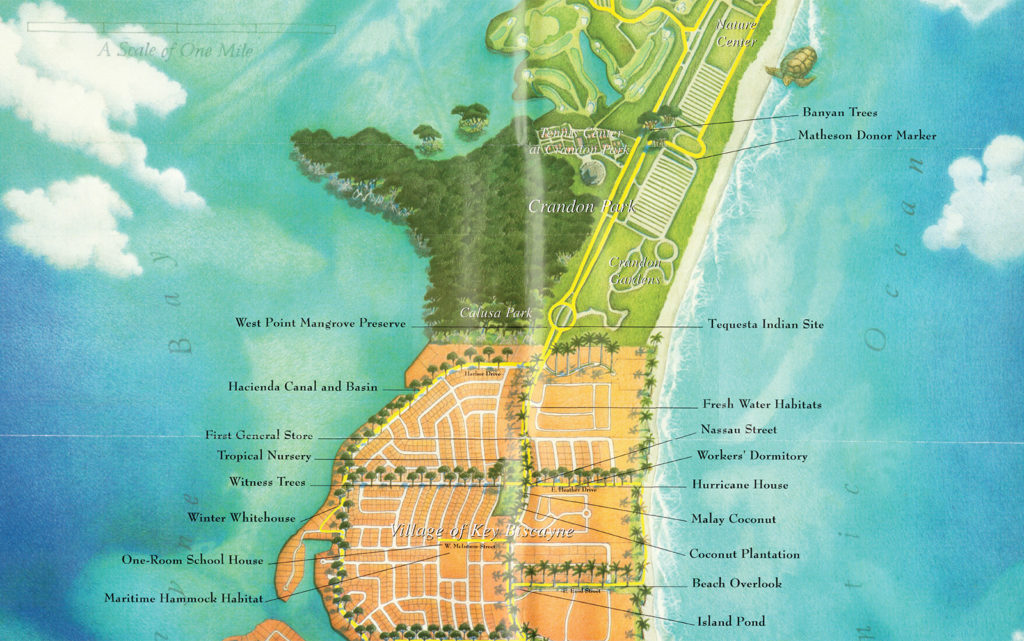
With characteristic reverence for local lore and appreciation for our distinctive Island heritage, in the late 1990s our local government, with a major initiation and support from our Island historian Joan Gill Blank, established the Key Biscayne Heritage Trail. Financed in part by a state historic preservation grant and honored with commendation by the American Association for State and Local History, the Heritage Trail is a self-guided tour from Bear Cut to Cape Florida and from Ocean to Bay, orienting the intrepid seeker on a geographic and historical journey of discovery. The trail is marked by the fertile image of a sprouting coconut palm (Cocos nucifera); a new tree from seed. A symbol of renewal in the tropics, this might also bring to mind our incorporation as the Village; an unlikely new municipal life emerging from the husk of county indifference and even opposition.

Follow the trail and walk in the footsteps of prehistoric natives, early planters, shipwreck speculators, entrepreneurs, and homesteaders drawn to our proto-paradise. Explore Cape Florida, an important place-name in the earliest history of the Americas. Visit the iron cupola by the Lighthouse, installed by an army engineer, George Meade, whose career-path placed him in command of the Union army at Gettysburg only a few years later. Check out the Davis family park, site of the Island’s first waterfront residence and nearby, where the caretaker’s cottage stood, the recorded birthplace in the early 1900s of the Island’s first known children of African descent. Visit the Keeper’s Cottage and cookhouse. Ready yourself for a hike up 109 steps to the top of the Lighthouse and gaze towards the Gulf Stream, imaging sailing ships racing to wreckage on the shoals or commerce in the Caribbean and beyond. Follow the natural paths traversed by the Tequestas. You may spot some of the same types of migratory birds John James Audubon cataloged around Cape Florida in 1832. Rest at No Name Harbor, a wildlife ecosystem and refuge for pirates, smugglers and happy hour.
Moving north, imagine the busy commercial wharf once at Hacienda Canal. Channel political history at the site of President Nixon’s Winter White House on Bay Lane. Imagine Vanderbilts, Carnegies and Mellons on their grand yachts enjoying Gatsby-era hospitality while visiting William J. Matheson and family at Mashta House. Imagine the tropical nursery and botanical research that flourished on Key Biscayne, hints of which may be seen in the towering Kapok, Baobab and other specimen trees in the Village Green and in Crandon Park. Imagine the thriving coconut plantation established in 1908, mementoes from which are in the collection of the Key Biscayne Historical and Heritage Society. Imagine the first general store and the original one-room schoolhouse, precursor to the 1950s vintage Key Biscayne Community School. Walk down Nassau Street—now East Heather Drive—and imagine a line of coconut trees shading the white-frame cottages housing Bahamian plantation workers, much the same as the surviving frame houses in Coconut Grove. Many remember the Worker’s Dormitory, whose second life was the original St Christopher’s-by-the-Sea before transforming into the Island’s first theatre, Calusa Playhouse. The Lake Park may bring to mind the freshwater wells and ponds noted by British surveyors in the 1770s and by Ponce de León more than 250 years earlier.
Continue north into Calusa and Crandon parks, past Mangrove preserves, winding through wetlands and our rich and diverse barrier island ecology. You will pass through archeological preservation zones protecting Tequesta fishing camp-sites discovered in 1992, dating circa 1,200 A.D. On the bay side, at the Links golf course near the 18th tee, you might find the 1855 Coast Survey Monument if your tee-shot goes astray. This is the sibling of a similar granite monument in Cape Florida, that together mark the northern and southern ends of the Island. Coastal surveyors used the markers to map reefs and keys between Key Biscayne and Key West. On the ocean side, you will encounter the Quiet Gardens, formerly a zoological park and an enchanting setting. Moving northward beyond the Biscayne Nature Center, you will come to Bear Cut and the prehistoric fossilized reef, Key Biscayne’s black mangrove “petrified forest,” carbon-dated to around 50 A.D.
Walking, jogging or bike riding, the Heritage Trail imparts a sense of place that one cannot fully appreciate from books or stories, or a car. The experience helps sharpen one’s appreciation for nesting sea turtles, aquatic birds sheltered in the Bear Cut preserves, and migratory birds who no doubt are as pleased to come upon Key Biscayne during flight from South to North America and back as are snowbirds arriving from the airport in February. One can better appreciate our felicitous lifestyle on Key Biscayne imaging fresh-water supported Tequesta villagers from Bear Cut to Cape Florida, 500 years before European discovery.
By merely taking a walk along the Heritage Trail, we can better appreciate this ecological treasure of sand, wetlands and hardwood, home to our species and others, between bay and ocean, at a favorable latitude right off the Gulf Steam. Island Paradise may take on a larger meaning the more we know about our own natural resources, wildlife and history. The Heritage Trail helps us explore our unique history. Even in the suburbanized built-environment that is the modern core of the Island, if we pause with discernment in the heart of the Village following the Art in Public Places self-guided tour, our sensibilities may be sharpened in a different way, reinforced by our public art installations, each alluding to our history and heritage in a particular way.
The Jose Bedia plazas imagine our place in nature along Crandon, our busy main road, illustrating our park-to-Village-to-park linkage and reminding us that Village life is rooted in and inseparable from our Island environment. The Sarah Morris Plaza and Reflecting Pools hold glimpses of beach and water, trees and breezes, fronds and shadows, and the peculiar wonderful quality of changing nature’s light and the glimmer of water. And the Pleated Gnomon, a place of repose, teaching tool and cosmological clock all in one, reminds us of our connection in time and nature — the seamless endless passage of time and cycle of life demonstrated by the earth moving through space; endings and ever-coming new beginnings.
The Heritage Trail reveals transient settlements giving way to a military camp, giving way to a plantation, giving way to a Village. It also brings to mind that the setting hasn’t changed so much. We see the same stars at night. Time is marked by the same tidal changes and similar shadows in morning and afternoon. Island Paradise rings true to us because we’re so interconnected with nature. And our public art reminds us of this and of the relationship between the transient and eternal; the built and natural. Enjoy it.


Responses
Peter Schumann
Mar 11
Thanks for the reminder how Paradise always we live.
Might it be worthwhile to reprint the map?
The comments are closed.